Northern Japan is still popping, and is likely to continue to do so frequently for months if not much, much longer. The following U.S. Geological Survey sites show where, and get updated routinely:
- Latest Earthquakes in the World - Past 7 days
- http://earthquake.usgs.gov/earthquakes/recenteqsww/ (map)
- Earthquake List for 10-degree Map Centered at 35°N, 140°E
- http://earthquake.usgs.gov/earthquakes/recenteqsww/Maps/10/140_35_eqs.php (list)
- 10-degree Map Centered at 35°N,140°E
- http://earthquake.usgs.gov/earthquakes/recenteqsww/Maps/degree10/140_35.php (map)
GeoDharmaYT's plate tectonics snippet from a BBC documentary (Earth: The Power of the Planet, c. Jan. 2008) illustrates the underlying mechanisms.
- plate tectonics (YouTube, GeoDharmaYT)
- http://www.bbc.co.uk/sn/tvradio/programmes/earthpoweroftheplanet/index.shtml
- http://www.plymouth.ac.uk/pages/view.asp?page=33688
- http://www.youtube.com/watch?v=ryrXAGY1dmE
- Deep Ocean Trenches and ... [t]he Ring of Fire
- http://platetectonics.com/oceanfloors/japan.asp

- "Computerized digital images and associated databases are available from the National Geophysical Data Center, National Oceanic and Atmospheric Administration, U.S. Department of Commerce, http://www.ngdc.noaa.gov/" (NOAA/NESDIS/NGDC/MGG-Frequently Asked Questions in Marine Geology and Geophysics).
- Eurasian,
- Okhotsk (arguably separate from the N. Am. plate),
- Pacific, and
- Philippine.
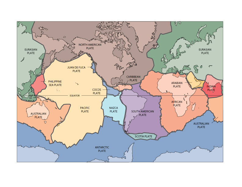
Source: U.S. Geological Survey, Moving slabs (USGS, This Dynamic Earth, c. 2008-09)
Shtuff happens where plates converge. Large earthquakes and aftershocks can cause tsunami capable of traversing and rebounding across oceans. In short, this puts people riding the plates, especially the edges of them, at risk. I hope this makes understanding the ride, if not immediate and consequential human losses, easier.
Reference
Muller, R.D., M. Sdrolias, C. Gaina, and W.R. Roest 2008. Age, spreading rates and spreading symmetry of the world's ocean crust, Geochem. Geophys. Geosyst., 9, Q04006, doi:10.1029/2007GC001743.

Pan due west from the starting point of the USGS Google Earth display of Earth's Tectonic Plates, and you should see not only the plates we're riding, but also locations for the "Japan Earthquake" and a M 6.1 aftershock east of northern Honshu, the long main island of Japan.
ReplyDelete